

Methodology
Marine ecological models will be used to track the nutrients in the sea, and trace back their riverine or oceanic sources with the transboundary nutrient transport method (TBNT). TBNT application is a prerequisite for distance-to-target requirement (DTTR) estimates. A generic watershed model applied to NEA rivers will calculate terrestrial nutrient exports to the sea under different scenarios:
- A past “pristine-like” scenario, where natural nutrient exports are estimated in the absence of human influence.
- Future “realistic” scenarios, where different urban wastewater treatments and agricultural practices are combined.
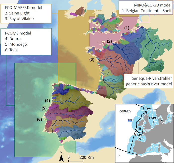
Map showing the domain of the river-basin SENEQUE/Riverstrahler model and the 3 coastal marine ecosystem models (MIRO&CO-3D, ECO-MARS3D and MOHID-LIFE) and their local implementation. The superimposed continuous line shows the 12 nm limit. Bottom right: geographical limits of the EEZ and OSPAR regions.
The river-basin model used in EMoSEM is SENEQUE/Riverstrahler (UPMC, Billen et al. 1994; Ruelland and Billen, 2005; Ruelland et al. 2007.)
The three marine ecological models used in EMoSEM are:
- MIRO&CO
- MUMM-ULB, Lancelot et al. 2005, Lacroix et al. 2007.
- See also MUMM Ecosystem models, OD Nature - REMSEM and AMORE.
- ECO-MARS3D
- Ménesguen et al. 2007.
- see also IFREMER.
- PCOMS
A detailed description of the project's workpackages is available.
See also:
References
Billen, G., Garnier, J. and Hanset, P., 1994. Modelling phytoplankton development in whole drainage networks: The RIVERSTRAHLER model applied to the Seine river system. Hydrobiologia, 289: 119-137.
Lacroix, G., Ruddick, K., Park, Y., Gypens, N. and Lancelot, C., 2007. Validation of the 3D biogeochemical model MIRO&CO with field nutrient and phytoplankton data and MERIS-derived surface chlorophyll a images. Journal of Marine Systems, 64(1-4): 66-88.
Lancelot C, Spitz Y, Gypens N, Ruddick K, Becquevort S, Rousseau V, Lacroix G, Billen G. 2005. Modelling diatom and Phaeocystis blooms and nutrient cycles in the Southern Bight of the North Sea: the MIRO model. Marine Ecological Progress Series 289 : 63-78.
Mateus, M., Riflet, G., Chambel, P., Fernandes, L., Fernandes, R., Juliano, M., Campuzano, F., de Pablo, H. and Neves, R., 2012. An operational model for the West Iberian coast: products and services. Ocean Science Discussion, 9: 1651-1689.
Ménesguen, A., Cugier, P., Loyer, S., Vanhoutte-Brunier, A., Hoch, T., Guillaud, J.-F. and Gohin, F., 2007. Two- or three-layered box-models versus fine 3D-models for coastal ecological modelling? A comparative study in the English Channel (Western Europe). J.Mar. Sys., 64: 47-65.
Ruelland, D., Billen, G., Brunstein, D. and Garnier, J., 2007. SENEQUE: a multi-scaled GIS interface to the RIVERSTRAHLER model of the biogeochemical functioning of river systems. The Science of the Total Environment, 375: 257–273.